Today's expeditions were positively the very last ones in our 2009 Sunday walks programme. They took the form of circular treks from Rigg End Car Park in High Castleton. The intent of the B-walk was to visit Carr House, Scale Cross, Park Nook, Rosedale Intake, Danby Lodge, Ainthorpe and Danby Church before returning back to our starting point at Rigg End.
We arranged to gather at Rigg End car park {NZ 680 077} in High Castleton by 10.00 am. Despite the very snowy conditions (see the picture below) some keen people managed to make it. We set off from the car park at about 10.05 am. There were three people in our group: JB, PB and KF. PB led the walk.
From the car park we headed in a south-westerly direction along the road towards Ivy Hall. At {NZ 678 074} we took a footpath on our right that led us in a northerly direction pass a disused quarry (on our left) to join a south-westerly path at {NZ 678 075} near some boundary stones. Turning left, we followed this path across the moor and downhill to cross a minor road at Carr House {NZ 675 074}.
After passing through the farmyard we followed a snow-laden path uphill in a south-westerly direction to meet a track at {NZ 669 068} near Dale View. This took us north towards an access gate onto Westerdale Moor at {NZ 669 070}. We now skirted around the south-west side of the moor in order to get to Dibble Bridge {NZ 676 078}. At the road we turned left and climbed up the hill, passing Maddy House as we went, in order to reach {NZ 671 083} where we took a footpath on our right. We followed this through the snow to reach another footpath on our right at Scale Cross {NZ 672 088}. This led us downhill to Commondale Beck {NZ 676 089} and, beyond it, the Middlesbrough-Whitby single-track railway line.
After crossing the railway we joined a south-easterly track near Box Hall {NZ 678 091}. We followed this to meet the Castleton road at {NZ 681 087}. From the road we took a snow-bound track that led us, via an old disused quarry, to Park Nook {NZ 685 086}. We now followed a snowy, icy and muddy track in an easterly direction through Danby Park to reach a path junction at {NZ 697 085}. From here we took a northerly track uphill to reach Pannierman’s Lane and then Pannierman’s Causeway. Now arriving at Rosedale Intake {NZ 706 094}, we decided to stop for a short lunch break.
After our lunch stop we made our way in an easterly direction to the minor road at {NZ 708 093} - just above the village of Danby. From here, we made our way along a series of tracks and paths to reach the North York Moors Centre at Danby Lodge {NZ 716 084}. Leaving the lodge on a southerly bearing we crossed the River Esk at {NZ 717 082} and the Middlesbrough-Whitby railway line at {NZ 715 081} in order to reach a minor road at {NZ 714 079}. Turning right onto this road we followed this to Kadelands House where we took a path on our left at {NZ 712 079}. This led us around several snow-laden fields to the small village of Ainthorpe {NZ 704 078}.
Turning left along the road, we climbed uphill - passing the Fox and Hounds public house (see here) on our left. We departed from the road at {NZ 705 075} by taking a south-going footpath on out right. This led us towards Bramble Carr {NZ 705 072} and on to Rowantree Farm {NZ 704 068}. We continued on our southerly bearing until we reached Plum Tree House {NZ 702 065}. From here we made a south-westerly trek to Church House {NZ 699 063}. We now turned left onto a minor road and followed this in a southerly direction. Just after the entrance to Lumley House (on our left), we took a public footpath on our right at {NZ 697 059}. This north-going footpath took us back towards Danby Church {NZ 696 063}. Just before arriving at the church we had a good climb up through the trees. After the climb, we decided that the church would be a good place to have a short tea stop - making good use of a conveniently located wooden bench near to the entrance to the church (with thanks to ‘Lucy Barker’).
From the church we took a northerly path across a snow-laden field to reach a gate at {NZ 695 065} near Wandels Lane. After passing through the gate we turned left and made a steep descent down a narrow lane to a road junction at {NZ 692 064} near Danby Beck. Surprisingly, and thankfully, the surface of this lane was completely free of snow and ice. Just after the bridge over Danby Beck, we turned right, leaving the road, in order to follow a north-going public footpath to {NZ 688 074}. At this point, we changed our bearing to a north-westerly one in order to get to Didderhow Farm {NZ 685 076}. Passing through the farm we now climbed up a very steep, slippery, icy lane in order to reach the road at High Castleton {NZ 683 078}. Turning left along this road, we made our final climb up to Rigg End car park to our cars.
After a little bit of ‘wheel spin’ on the icy surface, we all managed to get our cars off the car park onto the road in order to make our way home.
Well, what a great day we had. There were some tremendous views and I only made two (very minor) navigational slips (one near Rosedale Intake and the other near Plum Tree House). Of course, the snow, ice and mud made the ‘going’ quite difficult under foot; it was also sometimes very hard to find some of the footpaths in situations where they were buried deep beneath the snow.
Happy New Year! Welcome to SRC's first 2010 Sunday walks.
On Sunday, 3rd January, the Stockton Rambling Club will have three walks in the north-eastern area of the North York Moors. All walks will finish in Carlton in Cleveland {NZ 508 043} - see the following map.
Crown Copyright (2009). All rights reserved. Licence No. 100046831. Produced using Anquet Maps.
The A-walk will start at Osmotherley {SE 445 970} and will take in Whorlton Moor, Barker's Ridge, Carlton Moor and Cote House.
The B-walk will commence at Crathorne {NZ 443 075} and will visit Jamie Wood, Carr Hill, Whorlton and Carlton Bank.
The C-walk will also set off from Osmotherley and will pass through Scarth Wood, Swainby, Whorlton Hill and Faceby.
This is a Route 1 coach pick up and is also an early start (Billingham: 9.00 am, Stockton: 9.15 am and Acklam: 9.30 am).
Today's walks were the last on this year's SRC programme for which we should have had the support of our coach. Our expedition today should have taken us from Ormesby Bank {NZ 541 159} to Snow Hall Farm, Hall Hill, Newton Wood, Hutton Moor and Guisborough.
SQ and I waited patiently at the Littleboy pick-up point for the coach - from 9.15 am until 10.00 am. However, no coach appeared; I therefore rang the coach company to find out why our transportation was 45 minutes late. I was told that WM had rung up and cancelled the coach at 8.15 am!
Thanks for letting us know chaps!
In order not to waste such a lovely snowy, sunny day, I decided to do my own version of the (now cancelled) A-Walk - as outlined above - and at the same time do some geographing (see here). I therefore drove from Thornaby to Nunthorpe School and parked my car there for the day. I set off at about 10.40 am and walked to what would have been the start of the A-walk {NZ 541 159} (see the picture below) - had it actually taken place.
From the A171 road, I followed the track (Flatts Lane) in a north-easterly (becoming easterly) direction to reach the minor road at {NZ 552 164} near to Ten Acre Bank. Turning right, I followed the road in a southerly direction for about 300 yards to reach a footpath on my left at {NZ 552 161}. I followed this in an easterly direction across snow-laden fields to reach Mill Farm {NZ 563 160}. Now changing to a southerly bearing, I descended down the farm access track to reach the A171 dual carriageway at {NZ 563 157}. I crossed this in order to get to the public footpath that lay on the opposite side. I used this footpath to get to East Upsall Farm {NZ 562 153. From the front of the farm I navigated a route that took me to the old dismantled railway track at {NZ 558 147}.
Leaving the dismantled railway track on a southerly trek, I followed a very snowy route across the fields to the footbridge at {NZ 562 139} and then continued on to Snow Hall Farm {NZ 568 136}. After taking some photographs I took a southerly path from here and headed towards the church {NZ 569 133} at Hall Hill near Newton-under-Roseberry {NZ 570 131}. While in the area of the church I had a quick geographing session.
Passing through Newton-under-Roseberry, I made my way to Roseberry Lane at {NZ 570 129}. Turning into the lane I followed this in an easterly direction towards Roseberry Topping. Rather than skirt around it, I decided that I would do the climb up to the trig point on the top {NZ 579 126} - see the picture below. Bearing in mind the very snowy and slippery conditions, it was quite a pull up onto the summit. I would certainly not have attempted the ascent without my walking poles.
The views from the top were absolutely tremendous. Coated with a light dressing of snow, the trees in Newton Wood, and the village of Newton-under Roseberry, looked unreal - just like something from a Harry Potter film.
My descent from Roseberry Topping was much faster than my ascent. Using my walking poles for support, I more or less skied down the eastern side in order to reach Roseberry Common {NZ 583 127}.
In order to get an extra bit of steep climbing into my route, I decided to make my way up onto Newton Moor by climbing up the snow-bound Little Roseberry Hill {NZ 586 128}. Again, as was the case in my previous climb, the snowy conditions would have made this ascent extremely difficult without my walking poles. From the gate onto Newton Moor {NZ 588 127}, I followed the Cleveland Way (CW) in an easterly direction across Newton Moor to Hutton Moor {NZ 598 128}. From here I made my way to Black Nab and Highcliff Nab. I stopped at {NZ 611 136} for 5 minutes in order to partake of a quick drink and a sandwich.
I continued my trek along the CW in an easterly direction through Guisborough Woods until I reached a track junction at {NZ 622 144}. I now took the left-hand track and departed from the CW in order to descend down to Belman Bank {NZ 622 148}. I then followed the road into the car park in Guisborough to the point where the original A-Walk would have finished {NZ 615 159}. I arrived in Guisborough at 4.00 pm - just as it was getting dark. Of course, I now had to get back to my car which was located in Nunthorpe! Fortunately, I had my head-torch in my ruck-sack so the darkness and map reading were not real issues.
I made my way along Rectory Lane to a road junction at {NZ 607 154} and turned left. I now climbed uphill in order to reach a footpath at {NZ 603 149}. Following this in a westerly direction I made my way towards Hutton Gate where I came to a minor road at {NZ 597 147}. After turning left onto the road, I followed it for about 400 yards to reach the entrance to Home Farm {NZ 597 143}. From here I made my way along the route of the Tees Link (TL) footpath in a westerly direction in order to get to the visitors' centre at Pinchinthorpe {NZ 584 152}. I stopped here for five minutes for a quick drink and some rice pudding.
From the visitors' centre I continued to follow the route of the Tees Link footpath along the course of the old dismantled railway until I reached {NZ 568 151} near Low Farm. A this point the TL turned north towards Eston Moor while I continued on my westerly trek until I reached an 'operational' railway track near {NZ 555 146}. Because it was now 'pitch dark and I did not have a pre-programmed route in my GPS, I decided to make use of the snow-bound railway track near Morton Grange {NZ 554 146} in order to get to the public right of way (PRW) at {NZ 546 147}. Of course, I knew that there were no trains running on the Middlesbrough-Whitby line on Sundays during the winter months.
As I walked along the railway track in the dark, my head-torch picked up lots of animal foot-prints in the snow. These were probably caused by deer. When I reached {NZ 546 147}, I used the PRW to get to the A1043 road at {NZ 544 148}. Turning right, I followed this towards Swan's Corner. From here it was just a short walk back to my car at Nunthorpe School {NZ 542 155}. I arrived back at 6.20 pm.
During the course of the day I took about sixty photographs. A small collection of these can be seen using the 'Photos' button below. The full set of today's photos can be seen on the Geograph site[1] - including the ones I took while waiting for the coach that never turned up!
Notes
1 The complete set of today's photographs can be viewed on the Geograph Web Site (see here). In order to retrieve the pictures, you will need to do an 'Advanced Search' using the following values: Contributor='41502:Philip Barker', Taken between='20th December, 2009' and '20th December, 2009'. Enjoy!
On Sunday, 27th December, the Stockton Rambling Club will have two circular walks in the Castleton area of the North York Moors. Both walks will start and finish at Rigg End Car Park in High Castleton {NZ 680 077} - see the following map.
Crown Copyright (2009). All rights reserved. Licence No. 100046831. Produced using Anquet Maps.
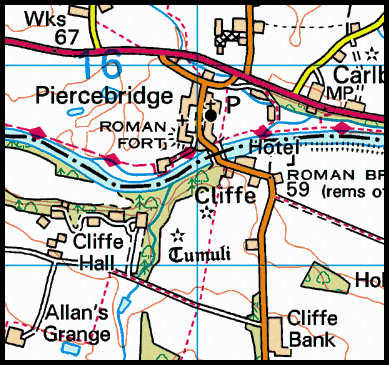
This week's Sunday expedition took us to the Piercebridge area of County Durham. From this location {NZ 210 158} we made a circular trek over the river into North Yorkshire and then visited Eppleby, Stanwick-St-John, Aldbough St John, Barton and Manfield before returning to our starting location.
We set off from our drop-off point (see the picture below) at about 10.00 am. There were 7 people in the group: PB, KF, CH, MH, LM WM and SR. WM led the walk.
From the village we headed south along the B6275 road and crossed the River Tees using the road bridge at {NZ 211 156}. Just after the bridge we took a public footpath on our right {NZ 211 155} which took us in a southerly direction along the edge of Kathleen Wood and over Betty Watson's Hill. We continued on our southerly bearing across open land until we reached a style at {NZ 210 148}. We turned right here and followed a good track in a westerly direction. We passed Cliffe Hall and the entrance to Home Farm as we made our way to Low Field {NZ 191 153}.
Continuing on our westerly trek we passed through Chapel House (where we met a very amiable farmer and his wife). We continued onwards pass the farm in order to reach a path junction in a field corner at {NZ 182 157}. Here we turned left onto a southerly bearing. We maintained this bearing across the fields until we reached Lower Chapel House {NZ 179 148}. From here we followed Curtain Lane until it met a minor road at {NZ 177 143}. Here we turned right and followed the road for about 260 yards to find a footpath on our left at {NZ 175 143}. We followed this in a southerly direction across the fields to reach the small village of Eppleby{NZ 178 132}.
We left Eppleby on a southerly bearing using a footpath that took us over Forcett Beck and the old dismantled railway line. This led us to a minor road at Forcett - near the site of Stanwick Camp {NZ 179 124} (see here). We decided to have our lunch stop here - sitting amongst the Iron Age fortifications.
After lunch we followed the Carlton road in an easterly direction for about 240 yards and then took a path on our right. This led us in a south easterly direction across the fields to the church at Kirkbridge. From here we followed the route of Mary Wild Beck to meet a minor road at {NZ 192 117}. After crossing this, we made our way across the fields in an easterly direction towards Aldbrough St John {NZ 202 113}. As we approached the village we saw a lovely bridge over Aldbrough Beck (see below).
We departed from the village on a south-easterly trek and made our way to Crossbury House and Micklow Hill {NZ 210 101} and onwards to the B6275 road near Hangbank Bridge {NZ 215 092}. From here we followed the course of Little Beck in an easterly direction towards the A1(M) motorway. We crossed this at {NZ 224 089} by means of a bridge. We then made our way in a south-easterly direction to the village of Barton where we had a short tea stop sitting at the foot of the village cross {NZ 229 088}.
Leaving the village on a north-westerly bearing, we crossed the A1(M) motorway (again) using the road bridge at {MZ 227 092} - this time going in the opposite direction to our previous crossing. We made our way to {NZ 224 094} (near Little Beck Bridge) where we turned right and headed north along a good track to reach Brettanby Manor {NZ 225 098} and, subsequently, Brettanby Farm {NZ 228 104}. At the farm we turned left and held a westerly bearing for about 400 yards before turning back onto a northerly heading. Now making our way north again, we passed Grunton {NZ 223 115} and then continued along Cottagers Lane (passing Manor Farm {NZ 221 131} on our right) in order to reach the village of Manfield {NZ 220 135}.
We navigated our way through the village in order to locate a north-north-easterly path that took us in the direction of the River Tees at {NZ 223 145}. Now taking a north-westerly bearing we made our way to Holme House {NZ 221 150}. Continuing our westerly trek we arrived at the B6275 road. Turning right, we followed this in a northerly direction, passing The George Hotel on our right, and then crossed the River Tees using the road bridge at {NZ 211 156} (see the picture below).
After crossing the river we took a footpath (on the east side of the village) that took us north to {NZ 211 159} where our coach was waiting to take us home.
Many thanks to WM for organising such an interesting and exciting adventure for us today. We had a really great time. Use the buttons below to see where we went, how we did and some of the sights we saw.
On Sunday, 20th December, the Stockton Rambling Club will have three walks in the Western Region of the North York Moors. All walks will finish in Guisborough {NZ 615 158} - see the following map.
Crown Copyright (2009). All rights reserved. Licence No. 100046831. Produced using Anquet Maps.
The A-walk will start at Ormesby Bank {NZ 541 159} and will take in Snow Hall, Newton Wood and Hutton Moor.
The B-walk will also commence at Ormesby Bank and will visit Eston Nab, Spite Hall and Highcliffe.
The C-walk will set off from the Cross Keys Inn {NZ 567 158} and will pass through Spite Hall, Cleveland Way, Highcliffe and Tees Link
This is a Route 1 coach pick up and is also an early start (Billingham: 9.00 am, Stockton: 9.15 am and Acklam: 9.30 am).
On Wednesday, 16th December, Stockton Rambling Club will have a mid-week walk in the Billingham Beck area of Teesside. Please meet at10.30 am at the Billingham Beck Car park - see the following map.
The walk will not be longer than 5 miles. For further details ring 01642-558198.
This is the second recent SRC walking expedition that has finished at Slapewath. Previously, in September, we walked up the coast from Loftus (see here for details). Today's route started in the village of Great Ayton and took us through Newton Wood to Roseberry Common and along the Cleveland Way (CW) to the Fox and Hounds Inn in Slapewath where we had a cooked meal.
Our coach dropped us off near the centre of Great Ayton {NZ 559 107} at about 10.15 am. There were 25 people in the group. PB led the walk. From the drop-off point we walked in an easterly direction towards the statue of James Cook (see picture below) and then made our way to a public footpath at {NZ 563 108} at the east-end of the village.
Our footpath took us in a north-easterly direction across the fields to the railway crossing at {NZ 571 112}. From here we climbed up to Rye Hill to meet a path junction at the southern edge of Cliff Ridge Wood {NZ 574 114}. Turning left, we now made our way through the wood on a north-westerly bearing until we reached a track at {NZ 568 118}. We turned right here and made our way uphill through Newton Wood {NZ 575 121} in the direction of Roseberry Topping.
Keeping the hill on our right, we skirted around Roseberry Topping in order to reach Roseberry Common {NZ 582 128}. From here we had a good climb up to Newton Gate {NZ 588 127} where we joined the Cleveland Way (CW) long-distance footpath. At this point we decided to take advantage of a boundary wall and the sunshine in order to take a short lunch stop.
Following our short lunch break sitting in the sun, we set off in an easterly direction along the CW to cross Newton Moor. As we approached Hutton Gate {NZ 597 129} we were overtaken by the B-group as it was making its way to Sleddale. After passing through Hutton Gate we crossed Hutton Moor in order to make our way to Black Nab {NZ 602 130}. From here we continued on our easterly trek to reach Highcliff Nab {NZ 610 138} (see the picture below).
After a short stop to take in the views from the above vantage point, we continued our trek along the CW. We passed through Guisborough Woods and emerged at {NZ 635 148} where we stopped for a short tea break. From here, the views of East Cleveland and the coast were quite spectacular.
Following our tea stop, we made our way along the CW to reach a good down-hill concrete track at {NZ 639 154}; this took us along the south-western edge of Spa Wood. As we were making our way down the track, the four people in the A-group over-took us. We stayed with the concrete track until we reached {NZ 637 155} when we took a footpath on our right. This took us around Spa Wood and onwards in an easterly direction to the small village of Charltons {NZ 645 157}.
Turning left, we now made our way along a westerly-going track (along the side of the A171 road) to reach the small village of Slapewath {NZ 642 158} and the Fox and Hounds hostelry (see the picture below) where our walking expedition ended.
Our coach was waiting for us in the car park and provided us with facilities for changing into our 'party clothes' prior to partaking of a meal in the carvery.
Many thanks to MT for organising such an interesting and enjoyable meal for us today. We also had a really good walk. Use the buttons below to see where we went, how we did and some of the sights we saw.
On Sunday, 13th December, the Stockton Rambling Club will have three circular walks in the Darlington area of County Durham. All walks will start and finish in Piercebridge {NZ 210 155} - see the following map.
Crown Copyright (2009). All rights reserved. Licence No. 100046831. Produced using Anquet Maps.
The A-walk will take in Eppleby, Stanwick, Aldbrough St John, and Barton.
The B-walk will visit Aldbrough St John, Barton, Grunton and Manfield.
The C-walk will pass through Aldbrough St John, Grunton and Manfield.
This is a Route 2 coach pick up and is also an early start (Billingham: 9.00 am, Acklam: 9.15 am and Stockton 9.30 am).
Following last week's exciting jaunt to Barnard Castle, today's expeditions brought us back to our own local terrain: the North York Moors - where our walking activity centred around the Castleton area.
Unfortunately, as a result of the torrential rainfall today, only ten people turned out for walking activities. Consequently, the three official SRC walks were cancelled. However, three of us (PB, JJ and LM) decided to do a modified C-walk (which PB would have led had our events not been rained off).
The original route of the C-walk would have taken us from Brown Hill {NZ 671 117} (see picture below) to Lealholm via Castleton, Ainthorpe, Danby Lodge and Houlsyke. This would have involved a distance of about 9 miles. Bearing this in mind, we added 'something' at the front, a few of loops in the middle and a couple of loops at the end in order to convert our route into a B-walk. Our relatively late start precluded extending our distance to that of an A-walk.
In order to facilitate our expedition we used two cars. We left one in the car park at Lealholm and the other in a small lay-by at Lockwood Beck (our new starting point) near the junction of Smeathorns Road and the A171 {NZ 674 139}. From this location we headed off (in pouring rain) in a southerly bearing along Smeathorns Road in the direction of Moorsholm Moor. After an uphill trek involving a climb of about 200 feet we arrived at the originally planned starting point for the C-walk near Brown Hill {NZ 671 117}. This initial trek along the road added about 1.4 miles onto what was to come later.
From the chevrons on the bend in Smeathorns Road, we continued our southerly trek over water-logged moorland to meet a minor road on Sand Hill at {NZ 668 107} - just east of Commondale. As we walked east along this road, some kindly, elderly gentleman stopped his car and asked us if we would like a lift anywere. We gracefully, gratefully and thankfully declined his offer and explained what great fun we were having. He must have thought we were crazy! We continued along the road for about 330 yards to find a westerly going public footpath at {NZ 670 106}. We followed this downhill to {NZ 668 102} and then turned left along a good track that took us on a south-easterly bearing to Moorside {NZ 671 100}.
We continued along the cart-track in a south-easterly direction. Our route now followed the railway track and Commondale Beck (both on our right and below us in the valley) until we reached Box Hall {NZ 677 092} and then the minor road at {NZ 681 087}. The original C-walk would now have gone down the road to Castleton station. However, at this point we introduced the first loop of the day. We crossed the road and followed a track up towards the disused quarries at {NZ 683 088} and then dropped down to Park Nook {NZ 685 086} - rejoining the road again at {NZ 684 085}.
Turning left, we passed under the railway bridge and crossed the River Esk using the road bridge. Judging by the volume of water flowing under the bridge, the river was obviously in spate as a result of all the rain that had fallen recently. We now followed the road uphill into the centre of Castleton where we took a short refreshment break for tea/coffee in Castleton Tea Rooms.
Leaving the tea rooms, we turned left and went downhill for about 140 yards and then, at the road junction, turned right and followed the road around towards Danby Low Moor. We did an anticlockwise half-circle around 'The Howe' in order to reach Howe Farm. From here we followed a public footpath in a south-easterly direction to meet a minor road at {NZ 699 075} - near the vicarage on Longlands Lane. Turning left, we went along the road for about 85 yards and then took a path (on our right) across the fields in order to reach the village of Ainthorpe.
We navigated our way through the village so as to find an easterly going track at {NZ 704 078} which we followed to a path junction at {NZ 712 078}. Turning left, we now headed north to reach a minor road (Easton Lane) and Kadelands House {NZ 711 079}. We followed Easton Lane in an easterly direction for about 260 yards and then turned left onto a north-easterly bearing in order to follow a public footpath. This took us across the railway track at {NZ 715 081} and the River Esk using a footbridge at {NZ 717 082}. At this point we undertook our second loop of the day - a diversion to The Moors Centre at Danby Lodge (see picture below). We were attracted to the Centre by the loud music that was being played there. As we found out when we got there, this was part of a Christmas Fair that was being held. We lingered here a while in order to sample the Christmas spirit.
Leaving Danby Lodge on a south-easterly bearing, we followed the road to {NZ 719 082} where we turned onto a footpath on our left. This took us across a water-logged field to Park House {NZ 722 081}. As we made our way through the farm buildings, we managed to find some shelter from the rain in an open barn within which we were able to take our long-overdue lunch stop.
From our lunch venue we followed the farm access track in an easterly direction to meet a minor road at {NZ 725 080}. We used this road to pass along Oakley Side in order to reach the small village of Houlsyke {NZ 737 080}. We passed through the village and continued along the road until we reached a path on our left at {NZ 740 078}. At this point we embarked on our third loop of the day. This loop took us to Lawns Farm {NZ 744 079} and Hole-i'-th'-Ellers {NZ 748 083}. From here we had intended to pass along the north- end of Park Wood. However when we got to the gate at {NZ 752 084}, we found the flooding at Park Head Beck was so great, we were not able to get across. This required us to re-route - via {NZ 751 085} - to a footbridge at {NZ 751 086}.
Once we had crossed the beck, we dropped down to Park Wood where we picked up the easterly going footpath at {NZ 753 084}. We now followed this to a path junction near Elm Ridge at {NZ 076 083} where we now joined the route of the original C-walk - which would have come along the south side of Park Wood on a path from {NZ 746 077}.
From the path junction we made our way downhill to the village of Lealholm {NZ 763 076} (see the picture below) where our expedition was to terminate. However, before finishing we decided to walk along the road from the car park area to the Shepherd's Purse and back. We then went over Lealholm Bridge (passing 'The Board Inn' on our right) in order to climb up to the road junction at {NZ 761 073}. We then returned to the car park in Lealholm. These were the final two loops of the day - and were needed in order to bring our mileage above 12 miles.
Although we were a little late setting off, and the weather was somewhat inclement, we had a great expedition to Lealholm today. Because of the heavy rainfall, we saw lots of 'watery scenes' that we would not have otherwise encountered. Indeed, as we approached Lealholm, the raging flood waters descending from the high-ground on the moors above Oakley Walls towards Park Wood were particularly spectacular and provided a challenge to our navigational skills.
Use the buttons below to see where we went, how we did and some of the sights we saw.
On Thursday, 10th December, Stockton Rambling Club will have a mid-week walk in the Bilsdale area of the North York Moors. Please meet at 10.30 am at Urra Farm in Bilsdale {NZ 571 019} - see the following map.
The walk will not be longer than 10 miles. For further details ring 01642-648682.