Thursday 28 January 2010

C-Walking: Swainby Strollers

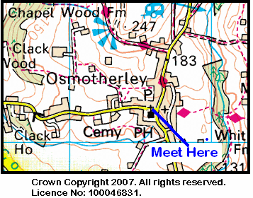
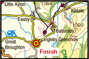
Bearing in mind the coach cancellations in early January, today's programme of walks was the first in 2010 to involve our usual three walk options. Our venue was the north-western region of the North York Moors (as defined in OS Sheet 26). The A-walk set off from Stokesley, the B-walk commenced at Ingleby Arncliffe and the C-walk departed from Swainby. The destination of all three walks was Ingleby Greenhow.

As mentioned above, today's C-route took us from Swainby {NZ 476 022} to Ingleby Greenhow via Faceby, Carlton in Cleveland, Kirkby and Great Broughton.

We set off from the public conveniences in Swainby at about 10.10 am. There were nine people in the group: DB, LB, PB, PI, CL, SQ, DR, DT and MT. PB led the walk.

Swainby
After crossing Scugdale Beck using the footbridge, we walked along the left-bank of the beck towards Holy Cross Church {NZ 477 020} where we turned left along Whorlton Lane. We followed the lane in a north-easterly direction, passing Whorlton Castle (on our left) and the church (on our right) to reach a footpath at {NZ 484 025}. Using this path, we climbed uphill around the western side of Whorl Hill towards the village of Faceby {NZ 496 031}. Just before entering the village we had a short coffee stop on the conveniently located outdoor seats at the north-eastern end of the village church {NZ 496 030}.

We walked through Faceby along the minor road that goes to the A172. At {NZ 495 033} we turned right, off the road, and headed in a north-easterly direction across the fields to Carlton in Cleveland. From here we had planned to take the public footpath at {NZ 509 043} opposite the blacksmith's shop. Unfortunately, we found that this path was not passable due to extensive flooding. This meant that we had to implement an unexpected diversion - see the map section below (the red line denotes the GPS tracklog).

Diversion-1
We re-joined our originally planned route at {NZ 513 045}. From here, we made our way across the fields to the village of Kirkby - where we had our lunch stop. Our route was not scheduled to go through the village itself; however, because the ground was so wet we diverted into the village in search of somewhere dry to sit.

Kirkby
The seating arangements for lunch necessitated that we split up into three small sub-groups - each one allocated to a particular bench within the village (one on the village green, one outside the church and one at the bus stop).

After lunch, we re-traced our steps back to our originally planned route at {NZ 539 058}. We now continued our north-easterly trek across the fields to reach a minor road at {NZ 545 063}. Turning right, we followed this road into Great Broughton {NZ 547 063}. Now walking in an east-north-easterly direction, we passed the village hall (on our left) and then took a public footpath on our right at {NZ 549 063}. Initially, this took us on a south-easterly bearing but then changed to an easterly direction in order to take us across the fields to Meynell Hall {NZ 564 062}.

Interestingly, as we passed through this section of the walk, and the next one towards Bonny Hill {NZ 569 054}, we encountered lots of fields containing a 'reed-like' crop which looked something like bamboo canes. We were informed by a local farmer that this was called 'elephant grass' - its technical name being 'Miscanthus'. Apparently, this is being grown as an experimental bio-fuel.

As we approached Bonny Hill, I noticed that the way-marked route of the footpath (which we followed) was different from the route as marked on both the digital and paper versions of the OS 26 maps (see the section of the digital tracklog below). I guess it's just as well we check out our walks before we do them!

Diversion-2
From Bonny Hill, we headed south to Beck House where we joined the minor road at {NZ 571 050}. From Beck House, I had planned to take the north-easterly path up to Bonnie Hill Farm. Unfortunately, I missed the turning onto the footpath and so I had to 'push on' as best I could using my map rather than my GPS!

Turning left onto the road (from Water Beck Farm) we trekked in a north-easterly direction to the road junction at Folly Farm {NZ 581 054}. Turning left into Lamb's Lane, we followed the road for about 200 yards and then turned right along the footpath towards Ingleby Manor. At {NZ 584 055} we turned left onto a northerly bearing and made our way across the fields to reach some smooth, 'slimey and slippery', stone steps. We descended these with care and then used the footbridge (rather than the ford) to cross Ingleby Beck and arrive at the church {NZ 581 062} - see the picture below.

Church at Ingleby Greenhow
The path now led us through the church grounds and up to the centre of Ingleby Greenhow {NZ 581 064} where our coach was waiting for us in the centre of the village.

Well, we had a really great day - full of interest and excitement. The weather was kind to us and, even though it was wet and muddy underfoot, we did not get any substantial volumes of rain.


Labels:

Monday 25 January 2010

Sunday Walking in County Durham

On Sunday, 31st January, the Stockton Rambling Club will have three walks in the Croxdale area of County Durham. All walks will finish in Durham {NZ 276 430} - see the following map. Click on the map to see a full version.

Map of the Byers Green to Durham area
Crown Copyright (2009). All rights reserved. Licence No. 100046831.
Produced using Anquet Maps.

The A-walk will start at Byers Green {NZ 223 341} and will take in Newfield, Weardale way, Scripton and Croxdale Hall.

The B-walk will commence at {NZ 215 356} on the A690 road and will visit Stockley Bridge, Tudhoe Lodge, Croxdale Hall and Shincliffe.

The C-walk will also set off from Byers Green and will pass through Burtons, Sunderland Bridge and Shincliffe.

This is a Route 3 coach pick up and is also an early start (Acklam: 9.00 am, Stockton: 9.15 am and Billingham: 9.30 am).


Labels:

Thursday 21 January 2010

Blackhall Beauties

The venue for this Sunday's walks (17th January, 2010) was the Blackhall Colliery {NZ 458 394} area of County Durham - with a meal to follow at the Hardwicke Hall Manor Hotel {NZ 450 392}. Although I had not planned to attend the culinary event, I thought this would be a lovely area to do a walk, take some photographs and, maybe, collect a few geograph points.

As I motored up towards County Durham along the A19, I was confronted with a beautiful blue sky, lots of sunshine and not a cloud in sight. I could not help thinking that this was probably the best 'walking day' we have experienced in 2010. What an absolutely marvellous day!

My first 'port of call' was the Hardwicke Hall Manor Hotel where I wanted to take a few photographs. As can be seen in the picture below, Duncan and the coach had already arrived at the venue.

Hardwicke Hall Manor Hotel
After a short 'walk-about' to take a few photos of the Hall and the nearby farm, I drove over to Blackhall Colliery {NZ 460 392} and then went south to the coastal car park near Blackwell Rocks {NZ 471 387} - where my circular expedition began. The car park gave me easy access to the Durham coast and the Durham Coastal Path (DCP).

From the car park, I headed north along the DCP - stopping to take photographs as and when necessary. Because of the remarkable weather, some of the coastal views were truly spectacular. At Castle Eden Dene {NZ 455 406} I saw the HM Coastguard having fun in the mud and water with their 4x4. I was amazed by the number of such vehicles there were on the beach in this stretch of the coastline - no doubt contributing to the erosion in the area.

HM Coastguard
I continued along the Durham Coastal Path until I reached Warren House Gill {NZ 442 426}. I now turned onto a westerly bearing and went inland (under the railway bridge) towards the B1283 road {NZ 438 425} at the northern end of the village of Horden.

I passed Horden Hall {NZ 433 424} on my right; I thought this was quite spectacular as it looked like something from a 'horror movie' - a typical haunted house! I continued on my westerly trek until I reached the cemetery {NZ 427 422} on the A1086 road - see the picture below. I now turned left and headed south towards the site of the Medieval Saxon Village of Yoden {NZ 430 416} (see here).

Cemetery
From the nearby, now dis-used, Peterlee Community Association building {NZ 431 416}, I navigated a route through the housing estates in the north-east part of the town towards the centre of Peterlee. Continuing on a south-easterly bearing I made my way to a path that took me into the Castle Eden Dene Nature Reserve at {NZ 437 400}. I crossed the dene with the aid of a bridge at {NZ 439 399}. As can be seen in the following picture, there was still plenty of snow about down here.

Bridge
After crossing the dene I climbed up a track on my left which took me up Craggy Bank to a footpath at {NZ 437 396}. From here I continued my south-easterly trek across the fields to reach a road junction on the B1281 road at {NZ 442 386}.

Rather than continue on my southerly bearing, directly to Hesleden, I decided to do an anti-clockwise half-circle. At the road junction I therefore turned right and went along the B1281 until I reached {NZ 437 385} where I turned back onto a southerly bearing - now walking along the eastern edge of grid-square NZ4338. Holding this direction for about 400 yards, I turned onto an easterly bearing at {NZ 438 382} and passed through the centre of the village of Hesleden {NZ 441 382}.

The final part of my expedition took me pass the communications mast on Mickle Hill (see the picture below) and back to the car park at Blackhall Rocks. I got back to my car at about 4.20 pm and it was still quite light.

Mickle Hill
Well, it was a lovely day for walking and a beautiful day for taking photographs. I managed to take 44 photos and capture 41 geographs - amongst these, there were some real beauties!


Labels:

Mid-Week Walking from Osmotherley

On Thursday, 28th January, Stockton Rambling Club have a mid-week walk in the Osmotherley area of the North York Moors. Please meet at 10.30 am in Osmotherley {SE 456 972} - see the following map.

Map of the Osmotherley area
The walk will not be longer than 10 miles.
For further details ring 01642-558198.


Labels:

Tuesday 19 January 2010

Sunday Walking to Ingleby Greenhow

On Sunday, 24th January, the Stockton Rambling Club will have three walks in the western region of the North York Moors. All walks will finish in Ingleby Greenhow {NZ 581 063} - see the following map. Click on the map to see a larger version.

Map of the Ingleby Greenhow area
Crown Copyright (2009). All rights reserved. Licence No. 100046831.
Produced using Anquet Maps.


The A-walk will start at Stokesley {NZ 525 086} and will take in Kirkby, Seave Green, Round Hill and The Incline.

The B-walk will commence at Ingleby Arncliffe {NZ 449 006} and will visit Swainby, Carlton and Great Broughton.

The C-walk will set off from Swainby
{NZ 581 063} and will pass through Cote House, Kirkby and Meynell Hall.

This is a Route 1 coach pick up and is also an early start (Billingham: 9.00 am, Stockton: 9.15 am and Acklam: 9.30 am).


Labels:

Thursday 14 January 2010

SRC on Twitter

Twitter is a useful mechanism for quickly sending out short messages that are 'instantaneously' delivered to (or can be accessed by) a group of 'followers'.

I have been exploring the use of this facility as a means of notifying members of SRC regarding walk cancellations or other similar types of eventuality.

Messages sent by Twitter are called 'tweets'. I have set up a message space called SRCtweet into which I can post messages either from my computer or from my mobile phone. This will enable rapid communication of (important) SRC news items to be posted and made instantaneously available to SRC members - either via a computer or a mobile phone. You can see SRCtweet in action by clicking here.

I have put a link to Twitter from the SRC Web page.

For anyone wanting to access the site from their (web-enabled) mobile phone, the links to use are as follows:
         http://twitter.com/SRCtweet
         http://m.twitter.com/SRCtweet
depending upon how you want to 'see' the messages displayed on your phone.

Of course, you can also arrange to set up a RSS feed to your computer and/or have a message 'texted' to your mobile phone one when one is posted on Twitter.


Labels:

Mid-Week Walking from Hartburn

On Wednesday, 20th January, Stockton Rambling Club have a mid-week walk in the Hartburn area of Stockton-on-Tees. Please meet at 10.30 am at the Masham hostelry in Hartburn {NZ 427 178} - see the following map.

Map of the Hartburn area
The walk will not be longer than 5 miles.
For further details ring 01642-895893.


Labels:

Tuesday 12 January 2010

Walk Cancellation

Due to the large amounts of snow on the North York Moors, this Thursday's mid-week walk in the Bilsdale area has been cancelled.

However, an alternative walk has been arranged. This will start off from Preston Park at 10.30 am and will be about 7 miles in length.

Ring 01642-648682 for more details.


Darlington Delights

Had our coach not been cancelled due to the inclement weather conditions, this Sunday's expedition (10th January, 2010) would have set off from Darlington {NZ 313 141}. Our trek would then have taken us to Piercebridge via Neasham Springs, Hurworth-on-Tees, Croft and Stapleton.

In order not to miss the delights of Darlington in the snow, I decided to make my way to where we would have started our trek - at the round-about on the B6280 road (Yarm Road) on the eastern approach to Darlington (see the picture below).

Darlington
From here I headed south down Salters Lane; this took me across Firth Moor to the railway bridge {NZ 312 123} and then the A66(T) road {NZ 312 128}. Just after crossing the road I turned east across some snowy fields in order to make my way over Hurworth Moor to East Flat Plantation {NZ 323 124}. I now took a south-south-easterly bearing in order to reach Low Maidendale Farm {NZ 325 121}.

Leaving the farm on a south-westerly trek, I made my way to Neasham Springs {NZ 321 113}. Continuing on a south-westerly bearing, my route now took me to the minor road near Spring Cottage {NZ 317 107}. Turning left, I followed the road in a south-easterly direction to a road junction on the west side of Neasham {NZ 323 101}. From the road junction, I picked up the route of the Teesdale Way long-distance footpath and followed this along the road in a westerly direction to reach Hurworth-on-Tees {NZ 311 101}.

As I reached 'The Otter and Fish' hostelry in the east-end of Hurworth, I turned left and crossed the River Tees using the bridge at {NZ 311 101}. I now followed a very snowy and icy farm track to Low Hail Farm {NZ 309 097} and onwards to the deserted farm house at {NZ 312 094} - see the picture below.

Farm house
From the deserted farm-house I now back-tracked to the bridge at Hurworth-on-Tees. I passed through the village in a westerly direction to find a north-going minor road (Roundhill Road) at {NZ 303 102}. I followed this to Ashfield Farm {NZ 304 112}, Holdforth Grange {NZ 302 122} and the round-about at {NZ 303 125} near Darlington Football Stadium (also known as 'Darlington Arena') - see the picture below.

Darlington Football Stadium
Keeping the stadium/arena on my right, I took a north-westerly road (Neasham Road) in the direction of the railway bridge at {NZ 299 130}. Passing under this, I continued to the round-about at {NZ 298 133} where I took the easterly-going exit - along Geneva Road. This took me pass East Cemetry (on my right) and on to the traffic lights at its junction with the B6280 road (Yarm Road) in Eastbourne {NZ 306 143}. Turning right, I followed the B6280 back to my starting point in the car park at the shopping centre at {NZ 314 142}.

I arrived back at my car thinking what I tremendous afternoon I had had. I experienced some exciting snow walking and had some wonderful photographic opportunities. My route today had been 'optimised' so as to visit as many different grid-squares as was possible in the time available - in order maximise the number of new geographs I could collect for this area.


Labels:

Monday 11 January 2010

Sunday Walking: New Year Lunch and Ramble

On Sunday, 17th January, the Stockton Rambling Club will have two walks in the Blackhall Colliery area of County Durham. These walks will finish at the Hardwicke Hall Manor Hotel {NZ 450 392} - see the following map.

Map of the Hardwicke Hall area
The B-walk will commence ... No details given.

The C-walk will set off from ... No details given.

Following the walks, lunch will be served at the hotel.
Participants on this event must pre-book.

This is a Route 3 coach pick up (Acklam: 9.30 am, Stockton: 9.45 am and Billingham: 10.00 am).
Note the pick-up times.


Labels:

Friday 8 January 2010

Mid-Week Walking in the Bilsdale area

On Thursday, 14th January, Stockton Rambling Club have a mid-week walk in the Bilsdale area of the North York Moors. Please meet at 10.30 am at the Chop Gate car park and village hall {SE 559 993} - see the following map.

Map of the Chop Gate area
The walk will not be longer than 10 miles.
For further details ring 01642-778247.


Labels:

Thursday 7 January 2010

Christmas Walking - Reflections

Despite the cold weather and the snow, there were some tremendous walks on offer from SRC over the Christmas period. Many thanks to Carole for all the organisational effort she put in.

Thanks also to all the leaders who did a really great job leading the walks. The leaders were: Carole-P, Chris-L, Ewan-R, Phil-J, Monica-C, Phil-B, Austin-B, Pauline-B and Margaret-K.

Ewan has written a wonderful reflection on the week's activities - nicely illustrated with photographs.

Click this link to see Ewan's reflections on the week's events.


Labels:

Tuesday 5 January 2010

Osmotherley Overview

This Sunday's walk (2010-01-03) was to be our very first walking expedition of the 2010 season of SRC events. It was based in the western region of the North York Moors. Our route should have taken us from the small village of Osmotherley {SE 456 972} to Whorlton Moor, Barker's Ridge, Carlton Moor, Cote House and Carlton-in-Cleveland - where our trek would have terminated.

Sadly, our coach was cancelled due to the snowy conditions. However, by mid-day the heavy snow-storms had stopped. I therefore decided to undertake a trip to Osmotherely in order to have a look at some of the beautiful winter sights that would not be on display during other, warmer, times of the year.

As is shown in the picture below, the approach road into Osmotherley from the west was quite clear. The roads I used to get to Osmotherly (via Stokesley) and return (via the A19) were also in a good condition - considering the amount of snow that had fallen.

Approaching Osmotherley
I drove around the village looking for a parking spot and eventually managed to find one on the opposite side of the road to the stone cottages depicted in the photograph shown below.

Osmotherley
From my 'docking' point I walked around the village taking various photographs of interesting snowy scenes. Sadly, there were more lovely things to photograph than there was time available.

As can be seen from the clock on the church tower in the following picture, there was probably only about one hour's daylight left before it would get too dark to take any more photographs.

Osmotherley Church
I therefore decided to make my way through the village to the village green and then go up the road in a northerly direction (towards Quarry Lane) in order to have a look at Cod Beck Reservoir. As can be seen in the following scene, this was nicely iced over - just like a 'giant' Christmas cake!

Cod Beck Reservoir
The snow-laden ground on the horizon in the above photograph is part of Whorlton Moor. This is where the A-walk would have gone - had the coach not been cancelled!


Labels:

Monday 4 January 2010

Sunday Walking to Piercebridge

On Sunday, 10th January, the Stockton Rambling Club will have three walks in the Darlington area. All walks will finish in Piercebridge {NZ 210 157} - see the following map.

Map of the Darlington-Piercebridge area
Crown Copyright (2009). All rights reserved. Licence No. 100046831.
Produced using Anquet Maps.

The A-walk will start at Darlington {NZ 313 141} and will take in Neasham Springs, Hurworth-on-Tees, Croft and Stapleton.

The B-walk will also commence at Darlington and will visit Neasham Springs, Hurworth-on-Tees, Croft and Stapleton.

The C-walk will set off from Hurworth-on-Tees {NZ 311 101} and will pass through Croft and Stapleton.

This is a Route 2 coach pick up and is also an early start (Billingham: 9.00 am, Acklam: 9.15 am and Stockton: 9.30 am).