A-Walking: Richmond Runner
Each of our three walks today (Sunday, 14th February) set off from the Sedbury layby on the west-bound carraigeway of the A66(T) road near Scotch Corner {NZ 208 053} - see the picture below. All of the walks subsequently finished in the beautifully situated town of Richmond {NZ 168 011} with its magnificent castle.

From the layby, the A-group made its way to Gilling West, Hartforth, Ravensworth, Kirby Hill, Sturdy House Farm, Willance's Leap, the Applegarths and Round Howe before finally arriving at its destination in Richmond.
We set off from our drop-off point at about 10.30 am.There were 6 people in the group: JB, PB, CH, JH, MS and WM. PB led the walk.
Taking an overall easterly bearing, we made our way through Sedbury Park and across the fields in order to reach Gilling West {NZ 183 052}. We crossed Gilling Beck and entered the village from the south side of the river.
After passing the church on our left, we departed from the village at {NZ 184 053}. Taking a north-easterly bearing we trekked towards and over Bayhams Hill {NZ 176 059} and then continued onwards to Hartforth {NZ 172 062}. Turning left, we followed Jagger Lane for about 155 yards and then turned right onto a good track. We maintained our north-eastly bearing along this track in order to reach the ford and footbridge over Hartforth Beck at {NZ 167 064}.
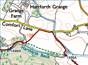
After crossing the beck we made our first navigational error of the day. Instead of turning sharp left and following the beck, we did an unintentional anti-clockwise half-circle around a field of turnips.

Crown Copyright (2009). All rights reserved. Licence No. 100046831.
Produced using Memory-Map.
Produced using Memory-Map.
After we had recovered the situation, we continued on our planned north-westerly bearing to Whashton Bridge {NZ 155 068} and the minor road at {NZ 145 076}. Turning right, we followed this road into Ravensworth {NZ 141 079} where we had lunch sitting in the sun on the village green. There was ample seating provided.
Following our very pleasant lunch stop, we headed south - passing Ravensworth Castle on our left. As we approached Kirby Hill {NZ 140 066}. we had our first major climb of the day. After the climb up to the village, we had some really good views of the terrain to the north of us - from where we had come.
Leaving the village on a southerly bearing, we continued to gain height until we reached the MOD land and the stile at {NZ 138 060}. We maintained our southerly bearing until we reached the road at Sturdy House Farm {NZ 137 050}. We followed the road (Sturdy House Lane) in a south-westerly direction to {NZ 135 047}. We now turned on to a bearing of 153° and followed Green Lane over High Moor to reach Silver Hill and Coalsgarth Gate {NZ 142 031}.
Maintaining our south-easterly bearing, we followed the public footpath along Coalsgarth Edge to reach a minor road at {NZ 151 022} near Beacon Cottage. We turned right, and in 140 yards turned left onto a south-going footpath at {NZ 150 022}. This took us across High Moor and eventually led us downhill to Whitcliffe Farm {NZ 152 015}.
At the road, we turned right and made our way in a westerly direction to High Leases {NZ 149 014}. We now climbed back up onto High Moor and, following a north-westerly path, we made our way to Willance's Leap {NZ 136 021}. We took a short tea stop here.
From the monument above Whitcliffe Scar we followed a muddy and slippery path in a westerly direction around to the road at {NZ 129 024}. We now used the access track to descend to the Applegarths {NZ 129 017} and the northern bank of the River Swale at {NZ 134 014}.

Now following the public footpath along the northern side of the river, we progressed to the southern edge of Whitecliffe Wood {NZ 145 010}. Passing through the wood on a good track, we made our way to Lownethwaite Farm {NZ 149 009} and the A6108 (Reeth Road) at {NZ 155 008}.
After crossing the road we made our way through the car park and used the footbridge at {NZ 157 008} to cross the River Swale. Passing Round Howe on our right,we maintained our easterly bearing to re-join the River Swale again at {NZ 165 006}. Now following the river-side path we followed the south side of the river to Richmond Bridge {NZ 170 006}.
Turning left, we crossed the river (once more) and then in 110 yards turned left again. This gave us a very good view of Culloden Tower in Temple Grounds {NZ 169 007} (see here). Turning right, our final ascent then involved a good climb up to the A6108 - using the road that runs along the eastern edge of Temple Grounds. After crossing the A6108, we had just a short walk to the car park in the centre of Richmond {NZ 168 011} where our coach was waiting for us.
Again, we had yet another interesting and exciting adventure today. Undoubtedly, we had a really great time - with so many interesting things to see and enjoy. Use the buttons below to see where we went, how we did and some of the sights we saw.


0 Comments:
Post a Comment
Subscribe to Post Comments [Atom]
<< Home