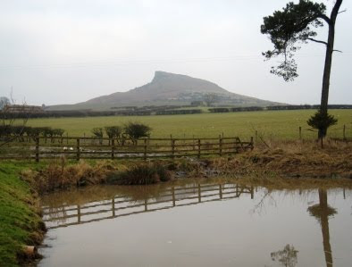
A-Walking: Stokesley Sprinter
Our walks today took us into the western region of the North York Moors. The A-walk started from Primrose Hill, the B-walk set off from Easby and the C-walk departed from Battersby Avenue. All walks finished in Stokesley.
From Primrose Hill {NZ 552 087}, the A-walk went to Red Hall, Ingleby Greenhow, Battersby, Kildale and Roseberry Common, Aireyholme Farm and Great Ayton before finally arriving at Stokesley.
We set off from our drop-off point at about 10.05 am. There were six people in the group: JB, PB, RB, KF, LM and WM. JB led the walk.

We left Primrose Hill on a south-easterly bearing towards Little Broughton {NZ 560 078} and the minor road at {NZ 560 068} near Red Hall. We continued on our south-easterly bearing to reach Meynell Hall {NZ 564 062}. Turning left onto an easterly bearing, we crossed Little Broughton Beck and continued across some very muddy fields to reach the minor road (Marsh Lane) at {NZ 572 065}. We then followed the road into and around Ingleby Greenhow {NZ 582 064}.
Leaving the village on a north-easterly bearing (passing the school on our right) we navigated around a series of fields in order to reach Station Farm {NZ 584 071} and Battersby Junction {NZ 588 072}. Now following a north-easterly path along the side of the railway, we found a bridge/tunnel at {NZ 591 076} that enabled us to pass underneath the railway line. We then zig-zagged (in an easterly direction) along some field boundaries in order to reach the small village of Battersby {NZ 596 076}.
Leaving the road at (NZ 598 077}, we continued in a north-easterly direction to {NZ 603 080}. We now turned left and walked on a northerly bearing to Low Farm {NZ 601 081}, Park Farm {NZ 602 085} and the minor road at {NZ 604 090}. Turning left, and in 190 yards turning right, we followed the road into the village of Kildale {NZ 608 094} where we had a short lunch stop in the shelter. There were just enough seats inside to accommodate the six of us.

After lunch, we left the village on a northerly bearing to pass under the railway bridge at {NZ 607 096}. Now following the route of the Cleveland Way (CW), we had a good climb up - passing Bankside Farm {NZ 605 101} as we went - to reach the high ground in Pale End Plantation {NZ 605 105}. Turning left, we now left the road and followed the CW in a westerly direction through the woods on Coate Moor in order to reach Captain Cook's Monument {NZ 590 101}. Turning right onto a northerly bearing, and staying with the CW, we dropped down to the car park at Gribdale Gate {NZ 592 110}.
From the car park we had another good climb up onto Great Ayton Moor. As we moved north along the Cleveland Way we encountered substantial volumes of snow and ice - which made the going underfoot quite difficult. At {NZ 592 124} we changed our bearing to 310° and headed for the gate at {NZ 588 127} on Newton Moor.
After a short 'catch-up' stop, we dropped down onto Roseberry Common and then left the CW at {NZ 583 127} by turning left in order to follow a track in a south-westerly direction to Aireyholme Farm {NZ 579 116}. We stopped here for our tea stop. Again the seating arrangements were just sufficient for the six of us - and the views that we had were quite spectacular.

We left our tea spot by following the farm access track in a downhill direction through Slacks Quarry in order to find a footpath on our right at {NZ 578 112}. We followed this in a north-westerly direction through Cliff Ridge Wood to reach a path junction at {NZ 574 114}. Turning left, we descended from the wood over Rye Hill to the railway track {NZ 571 112} and the minor road at {NZ 563 108} on the eastern side of the village of Great Ayton.
We navigated a westerly-going route through the village and crossed the River Leven using the footbridge at {NZ 555 105}. Turning left, we continued our trek along the minor road (Yarm Lane) to reach a footpath on our left at {NZ 552 104}. We followed this in a westerly direction to meet the A172 road at {NZ 531 090}. After crossing the road, we followed the footpath towards the centre of Stokesley. At the roundabout on the B1257 road, we turned left and followed the road in a south-westerly direction for about 150 yards to where our coach was waiting for us {NZ 528 086}.
Many thanks to JB for organising such an interesting and exciting adventure for us today. We had a really great time. Use the buttons below to see where we went, how we did and some of the sights we saw.
Labels: A-Walking: Stokesley Sprinter


0 Comments:
Post a Comment
Subscribe to Post Comments [Atom]
<< Home