A-Walking: Weardale Wonderland
Our three SRC walking expeditions this week (4th April) each took place in the Weardale area of County Durham. The A-Group set off from near Fir Tree on the A68 road; the B-Group made its start at Eels Bridge on the A689 road; and the C-Group set off from Wolsingham. All walks finished in Wolsingham {NZ 076 372}.
After setting off from Fir Tree, the intent of the A-Group's expedition was to visit Low Harperley, Bedburn, Potato Hill, Pikeston Fell, White Kirkley and Frosterley before arriving at our final destination in Wolsingham.
We set off from our drop-off point on the A68 {NZ 138 347} at about 10.45 am. There were five people in the group: JB, JPB, KF, CH and PB. PB led the walk.
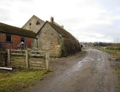
Leaving the A68 road on a south-westerly bearing, we made our way to Hollin Hall {NZ 136 345} and then Wadley Farm {NZ 132 339} where we joined the Weardale Way (WW) - see the picture below.

Turning right, we followed the route of the WW in a north-westerly direction to reach Low Harperley {NZ 119 349}. We crossed the River Wear using the footbridge at {NZ 117 345} and then headed south towards Low Shipley {NZ 116 340}, and then, onwards to Middle Shipley {NZ 118 334}. Continuing on our southerly trek, we made our way to Carrwood Hill {NZ 118 323} and then crossed Bedburn Beck using the footbridge at {NZ 117 322}. From here we followed a bearing of 210° in order to reach Snape Gate {NZ 116 319}. Now turning onto a bearing of 256°, we made our way to Bedburn {NZ 101 316} by following the footpath on the south side of Bedburn Beck. This path enabled us to take in both Howlea Bridge {NZ 111 319} and the caravan park at Newhall Farm {NZ 106 319}.

We crossed the river at Bedburn Bridge {NZ 101 316} and continued on our south-westerly bearing (still following the course of Bedburn Beck) - but now using a footpath on the northern side of the stream. This led us into the north-eastern part of Hammsterley Forest near the visitors' centre {NZ 093 312}. We decided to take our lunch break here, at the picnic spot, so that we could take advantage of the seating arrangements that were on offer.
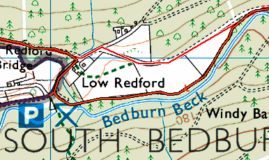
After lunch we set off along the forest drive in the direction of Low Redford {NZ 081 310}. As we were passing Low Redford Wood {NZ 086 311}, I was 'forced' to deviate from my intended route (the red line in the map below) in order to follow a walkway along the beck (orange line). Unfortunately, this added a little extra distance to the planned route - but it was much more scenic.

Crown Copyright (2009). All rights reserved. Licence No. 100046831.
Produced using Memory-Map.
Produced using Memory-Map.
After re-joining the planned route at Low Redford, we continued along a lovely forest track in a west-north-westerly (WNW) direction through North Plantation. This path followed the course of Ayhope Beck to {NZ 071 313} where we then turned left and crossed over it using the footbridge near the picnic site. From here we had a gentle climb up to a track junction at {NZ 068 310} on Potato Hill. Turning back onto our WNW bearing, we crossed Hamsterley Common - now making for the Meeting of the Grains near {NZ 051 316}.
We crossed South Grain Beck using the ford at {NZ 050 316}. Now heading in a northerly direction, we started our climb up onto Pikeston Fell. Undoubtedly, this was the major climb of the day; the severity of the incline was tenaciously augmented by the depth of the heather that we encountered. Despite this, the views and scenery were really wonderful.
As we made our way north, We crossed North Grain Beck at {NZ 046 326} and then steered a zig-zag course to the trig point on top of the fell {NZ 038 339}. We zig-zagged in order to minimise the amount of deep heather that we had to trek through. As we approached the trig point (see the picture below) we were further 'punished' by the very strong, cold winds that were waiting to welcome us.

From the high ground, we had some really tremendous views down into Weardale. We started our descent by dropping down to Allotment House {NZ 031 343}. Because of the strong winds that we were still experiencing, we delayed our tea stop until we reached Folly Plantation {NZ 030 347}. At this point, the dry-stone walls and trees on each side of the road provided us with some shelter from the strong, cold winds that were still buffeting us.
After our short tea stop, we continued our descent in a northerly direction in order to reach White Kirkley {NZ 027 359}. We continued down the road to the bridge over Bollihope Beck {NZ 026 360}. After crossing the beck, we turned right and followed a footpath in a north-easterly direction towards Frosterley.
We reached the south bank of the River Wear near {NZ 032 367}. From here we followed the riverside path in an easterly direction to Wolsingham Bridge {NZ 075 368}. We used this to cross the River Wear and then followed the Wheelchair Walk into the centre of Wolsingham {NZ 076 372} (see the picture below) where our coach was waiting for us.

Even though some of the route today was quite hard going, we had an interesting and exciting adventure. And, of course, the Weardale scenary was wonderful. Use the buttons below to see where we went, how we did and some of the photos.
Labels: A-Walking: Weardale Wonderland


0 Comments:
Post a Comment
Subscribe to Post Comments [Atom]
<< Home