Saturday 30 October 2010

A-Walking: Downholme Delights

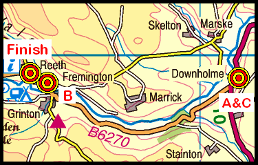
Our three expeditions this week (Sunday, 24th October) each took place in the Swaledale area of North Yorkshire. Both the A-Walk and the C-Walk each set off from Downholme Bridge and the C-Walk commenced at Fremington. All three walks finished at Reeth.

After leaving Downholme Bridge {SE 113 991}, the intent of the A-Walk was to visit Marske, Orgate Farm, Helwith Bridge, Holgate, Schoolmaster Pasture, Langthwaite, Fore Gill Gate and Riddings Farm before arriving at our final destination in Reeth {SE 038 992}.

We left our drop-off point at about 10.50 am. There were initially eight (but later nine) people in the group: JB, PB, RB, RGC, KF, CL, LM, WR and JT. JB led the walk.

From the lay-by on the A6108 road beneath White Scar, we walked in a southerly direction towards Downholme Bridge where we crossed the River Swale. Taking a footpath on our right at {SE 112 991}, we headed in a north-north-westerly direction across the fields to reach the minor road at {NZ 107 000} near Cat Bank. We followed the road in a north-westerly direction into the village of Marske {NZ 104 004}.

Approaching Maske
Maintaining our north-north-easterly bearing, we made our way through Clints Wood to Orgate Farm {NZ 092 018}. A little further north we crossed Marske Beck using a stone, arched bridge at {NZ 088 023} and then made our way to Telfit Farm {NZ 086 025}.

At {NZ 085 028} we changed onto a westerly bearing and followed the route of Marske Beck in order to reach Helwith Bridge {NZ 074 028} where we crossed the beck. Changing to a north-westerly bearing we made our way across the fields (via Hell Holes) to the farm at Holgate {NZ 067 038} - see the picture below. Leaving the farm area, we dropped down to the bridge at Holgate Beck {NZ 065 039} - known as Goats Bridge. We stopped here for a short lunch break - sitting on the bank of the stream.

Holgate Farm
From our lunch-stop location, we climbed up to {NZ 060 034} and then turned onto a northerly trek in order to reach the farm at Schoolmaster Pasture. At this point, we had a good view of the B-Group ahead of us. At the farm, we changed to a west-north-westerly bearing to reach the disused pits at {NZ 049 043}.

Having now overtaken the B-Group, and having acquired an extra member to our group (WR), we made our way over Moresdale Ridge using a good track (Moresdale Road) until we reached St Andrew’s Cross {NZ 033 040}.

Just after the cross, at {NZ 026 040}, we left the track and followed an ill-defined bridleway that took us over some rough moorland - to re-join the route of our original track at {NZ 018 040}. We continued along the track to reach the cairn on the high ground near {NZ 010 039}. From here we made a gradual descent in a southerly direction to reach the path junction at {NZ 008 033} - see the picture below. Turning right, we now made a steep descent to the footpath junction at Windegg Lane {NZ 004 034}.

Bridleway from Low Moor
At the path junction we turned left and headed south to reach the village of Langthwaite {NZ 005 024}. Just after passing through the village we stopped for a short tea-stop - sitting on the reinforced east bank of Arkle Beck {NZ 005 024}.

Continuing on a south-easterly bearing along the riverside, we crossed over the beck using the footbridge at {NZ 010 020} and made our way in a westerly direction to the minor road in Arkle Town {NZ 007 018}. Continuing on a south-westerly bearing we headed up through Fore Gill to reach Fore Gill Gate {NY 993 009}. From here we followed a good track in a south-easterly direction that took us around the southern side of Calver Hill to reach Riddings Farm {SE 027 997}.

Riddings Farm
After passing the farm on our right, we joined Skelgate Lane at {SE 030 996} and followed this to emerge on the B6270 at {SE 035 993}. Turning left, we followed the road in an easterly direction into the centre of Reeth {SE 038 992} where our coach was waiting to take us home.

Many thanks to JB for organising such an interesting and exciting adventure for us today. We had a really great time. Use the buttons below to see where we went, how we did and some of the photos.


Labels:

Friday 29 October 2010

Early-November Mid-Week Walking
2010-11-04

On Thursday, 4th November, Stockton Rambling Club will have a mid-week walk in the Sandsend area of the North York Moors. Please meet at 10.30 am at Lythe Bank Car Park {NZ 860 126} - see the following map.

Map of the Lythe Bank area
Crown Copyright (2010). All rights reserved. Licence No. 100046831.
Produced using Anquet Maps.

The walk will not be longer than 10 miles.
For further details ring 01325-469476.


Labels:

Monday 25 October 2010

Sunday Walking to Whitby

On Sunday, 31st October, the Stockton Rambling Club will have three walks in the south-eastern area of the North York Moors region. All walks will finish in Whitby {NZ 898 110} - see the following map.

Map of the JuggerHowe-Whitby area
Crown Copyright (2010). All rights reserved. Licence No. 100046831.
Produced using Anquet Maps.

The A-walk will start at Sneaton Corner {NZ 892 078} and will take in Billira Cottage and Robin Hood's Bay

The B-walk will commence at Jugger Howe {NZ 944 003} and will visit Ravenscar and the Cleveland Way.

The C-walk will set off from Hawsker {NZ 928 075} and will pass through Park Gate and Robin Hood's Bay.

This is a Route 1 coach pick up and is also an early start (Billingham: 9.00 am, Stockton: 9.15 am and Acklam: 9.30 am).


Labels:

Friday 22 October 2010

A-Walking: Stanhope Struggle

Our three expeditions this week (Sunday, 17th October) each took place in the Weardale area of County Durham. The A-Walk set off from West Stanhope, the B-Walk started at East Stanhope and the C-Walk commenced at Eastgate. All three walks finished at St John's Chapel.

After leaving Stanhope {NY 991 393}, the intent of the A-Walk was to visit Heathery Burn, East Whiteley Burn, Steward Shield Meadow, Bolt's Law, Whiteheaps Dam, Groove Rake, Scarsike Head and Westgate before arriving at our final destination in St John's Chapel {NY 884 379}.

We left our drop-off point at about 11.00 am. There were eight people in the group: JB, KB, PB, KF, CH, CL, AM and LM. PB led the walk.

From the A689 road we followed the B6278 minor road in a northerly direction for about 220 yards. We then turned left along a footpath at {NY 991 395} which took us down to Stanhope Burn. After crossing the stream using the footbridge at {NY 990 395} we followed the footpath in a north-westerly direction towards Widley Field {NY 986 402} - see the following picture.

Widley Field
We continued along the riverside footpath to reach a second footbridge at {NY 986 403} where we crossed back over to the east side of the burn. Turning left, and moving along a good track in a northerly direction, we made our way to the old Fluor-spar mine at {NY 986 413} near Heathery Burn.

Continuing on our northerly trek along severely eroded footpaths, we made our way to East Whiteley Burn {NY 987 426} where we turned onto a north-westerly bearing in order to reach the confluence of West Whiteley Burn with Stanhope Burn {NY 983 430}. As we approached the confluence of the two streams, we sighted a beautiful heron flying upstream away from us.

From the river confluence, we started our first major climb of the day. This took is up to the farm at Steward Shield Meadow {NY 983 438} and upwards to reach the old dismantled railway track at {NY 983 443}. Turning left along the track, we followed this in a west-north-westerly direction to reach the sheepfold at {NY 952 450} - see the picture below. As we trekked to the west, we experienced strong, cold head-winds. We therefore decided to use the sheepfold as a shelter for our lunch stop.

Sheepfold
Leaving our lunch-stop location on a northerly bearing, we passed by Bolt’s Law on our left and navigated a route that took us to the (now disused) Fluor-spar mine at {NY 947 466}. Turning onto a westerly bearing, we walked along the edge of Whiteheaps Dam {NY 945 465}. From here we followed a south-westerly bearing over moorland terrain to reach a minor road at {NY 936 456}. As we trekked over the moor, we had some good views of Burnhead Dam on our left - to the south of us. Crossing the minor road, we continued our south-westerly trek through the heather-laden moorland to reach the junction of the boundary fences on Cuthbert’s Hill {NY 929 452}.

Because of the substantial heather growth on the route of the public footpath from Cuthbert’s Hill, we decided to follow an alternative path which lay on the north side of the boundary fence. We followed this in a west-south-westerly direction towards Dry Rigg {NY 906 447}. Just before reaching the trig point at {NY 913 449}, we turned left and headed south to re-join the public right-of-way at {NY 915 446}. We now followed this in order to reach Rookhope Chimney Track {NY 906 442} where we stopped for a short tea break. We were now conscious of the fact that we were running late as a result of the strong head-winds and under-foot conditions that we had been exposed to.

Rookhope Chimney Track
From the tea-stop location, we descended in a west-south-westerly direction over wet and muddy moorland terrain to reach the minor road at Groove Rake {NY 896 441}. Turning left, we followed the road in a south-easterly direction to reach a footpath on our right at {NY 903 432}. Following this path, we crossed Rookhope Burn at {NY 902 432} and then headed in a southerly direction, uphill, to the farm at Wolf Cleugh {NY 901 426}. Now switching to a south-easterly bearing, we made our way over the moorland to reach a road junction at {NY 910 413} on Scarsike Head. Leaving the road using the ladder-stile at {NY 910 412}, we trekked on a south-south-westerly bearing to reach a broad track at Whitley Hills {NY 905 403}. Heading in a southerly direction along the track, we followed this for about 240 yards and then turned right along a footpath that took us to Middle Hope. Turning left at {NY 905 400}, we now followed the course of Middlehope Burn in a southerly direction to reach Westgate {NY 906 382}.

Middlehope Burn
Turning right at, we followed a westerly going public footpath to {NY 901 381} where we turned left onto a southerly bearing that took us over the River Wear using the footbridge at {NY 901 379} to reach the Weardale Way. We followed this in a westerly direction to arrive at the A689 road at Daddryshield Bridge {NY 895 380}. We turned left here and followed the A689 road through Daddry Shield {NY 894 378} to reach St John’s Chapel where our coach was waiting for us. Sadly, we arrived at our destination about 30 minutes late.

We really struggled to get back within our allotted six-hour time slot. However, the elements were against us. We experienced quite strong winds on the high ground; these together with extensive sections of heather and bad conditions under-foot slowed us down quite considerably. Bearing this in mind, I would like to offer my sincere apologies to our coach driver and the other walkers for keeping them all waiting.

Use the buttons below to see where we went, how we did and some of the photos.


Labels:

Thursday 21 October 2010

Late-October Mid-Week Walking
(2010-10-28)

On Thursday, 28th October, Stockton Rambling Club have a mid-week walk in the Guisborough area of the North York Moors. Please meet at 10.30 am at the Pinchinthorpe Visitor Centre {NZ 584 153} - see the following map.

Map of the Pinchinthorpe Visitor centre area
The walk will not be longer than 10 miles.
For further details ring 01642-313138.


Labels:

Monday 18 October 2010

Sunday Walking to Reeth

On Sunday, 24th October, the Stockton Rambling Club will have three walks in the Swaledale area of North Yorkshire. All walks will finish in Reeth {SE 038 993} - see the following map.

Map of the Downholme Bridge area
Crown Copyright (2010). All rights reserved. Licence No. 100046831.
Produced using Anquet Maps.

The A-walk will start at Downholme Bridge {SE 113 982} and will take in Holgate, Moresdale Road and Force Gill.

The B-walk will commence at Fremington {SE 046 989} and will visit Washfold, Moresdale Road and Langthwaite.

The C-walk will also set off from Downholme Bridge and will pass through Marrick Abbey, Grinton and Scabba Wath

This is a Route 2 coach pick up (Billingham: 9.30 am, Acklam: 9.45 am and Stockton: 10.00 am).


Labels:

Wednesday 13 October 2010

A-Walking: Castleton Crescendo

This was the second of two A-Walks that took place during the SRC walking weekend that was held at Castleton in Derbyshire.

Our three expeditions on Sunday, 10th October each took place in the Castleton area of the Peak District. All three circular walks started and finished at the Youth Hostel in Castleton.

After leaving Castleton {SK 149 828}, the intent of the A-Walk was to visit Spring Farm, Lose Hill, Hollin's Cross, Mam Tor, Sparrowfit, Old Dam and Cave Dale before arriving at our final destination in Castleton.

We left our starting point at about 9.40 am. There were nine people in the group: PB, RB, JC, JH, CL, LM, AM, BT and JT. PB led the walk. Before setting off, we welcomed a new A-walker (BT) to the group.

We left the Youth Hostel on a northerly bearing passing through the Church grounds in order to reach the road junction at {SK 150 830}. Moving down Millbridge, we continued in a northerly direction for a further 130 yards and then turned onto a north-westerly trek along Hollowford Road. At {SK 147 834}, we turned right onto a north-easterly bearing and made our way across the fields to Spring House Farm {SK 156 840}. Turning north we started our first major climb of the day up to Crimea Farm {SK 158 846} and onwards up onto Lose Hill {SK 152 853}.

Lose Hill
Leaving Lose Hill on a west-south-westerly bearing, we made our way to Back Tor {SK 145 849} and along Barker Bank {SK 140 846} to Hollins Cross {SK 135 845}. We continued on a south-westerly bearing to reach the ridge near Cold Side {SK 129 841} and then climbed up onto Mam Tor {SK 127 836}. This was the second and final major climb of the day.

Mam Tor
From the trig point (OSBM S4230), we headed on a south-westerly bearing to the minor road at {SK 125 834}. Now changing to a westerly bearing, we made our way to Lord’s Seat {SK 112 834}. Continuing in a west-south-westerly bearing along Rushup Edge, we followed a good track to reach a minor road at {SK 093 825}. We continued along the footpath along the side of the road for about 150 yards to reach the Pennine Bridleway {SK 091 824}.

Turning left along the bridleway, we followed a narrow lane downhill to near the entrance to Rushop Hall {SK 094 821} where we turned right onto a southerly bearing. From here, we followed a footpath across the fields to Rushop Farm {SK 091 812} and the small village of Sparrowpit (SK 090 807). We stopped at the The Wanted Inn for a glass of lemonade and a lunch stop.

Pub in Sparrowpit
Leaving the village on an easterly bearing we made our way to the wood near Gautries Hill {SK 098 807} and, passing through this wood, arrived at a minor road in Perry Dale {SK 106 807}. Turning right along the road, we followed this into the small village of Old Dam {SK 115 796}.

We left the village in an easterly direction along Old Dam Lane. At {SK 120 795} we turned left along a farm access track (and public bridleway) that took us in a north-easterly direction to Oxlow Rake {SK 124 799}. Climbing up towards Oxlow Dam {SK 127 801}, we joined a walled track that took us to the Limestone Way (LW) at {SK 132 806}.

We continued on a north-easterly bearing along the LW which took us over Old Moor to the track junction at {SK 135 813}. Maintaining our north-easterly bearing, we progressed to {SK 139 816} where we started our descent, still with the LW, into Cave Dale and its impressive rock formations.

Castle above Cave Dale
As we descended along the stony track to Castleton, we had some impressive views of the remains of Peveril Castle - looming high above us {SK 149 826}.

Use the buttons below to see where we went, how we did and some of the photos.


Labels:

A-Walking: Edale Ecstacy

This was the first of two A-Walks that took place during the SRC walking Weekend at Castleton in Derbyshire.

Our three expeditions on Saturday, 9th October, each took place in the Vale of Edale area of the Peak District. The three walks each set off from Edale Station. Being circular walks, the A-Walk and the B-Walk each returned to this location. The C-Walk finished in Castleton.

After leaving the car park at Edale Station {SK 123 853}, the intent of the A-Walk was to visit Upper Booth, Jacob's Ladder, Kinder Low, Kinder Downfall, Kinder Reservoir Edale Cross, Brown Knoll and Barber Booth before arriving at our final destination back at Edale Station.

We left our drop-off point at about 9.55 am. There were five people in the group: PB, RB, JH, LM and JT. PB led the walk.

We set off from the car park at Edale Station in a northerly direction along the road to the village of Edale {SK 123 855}. At the start of the Pennine Way (PW), in Grindsbrook Booth {SK 122 859}, we turned right and followed its route across the fields to Upper Booth {SK 102 852}. Leaving Upper Booth in a westerly direction, we continued along the PW on a north-westerly bearing to the footbridge at {SK 088 861} - see the picture below.

Footbridge
From here we had a good climb up Jacob’s Ladder to reach the footpath junction at {SK 080 861}. Turning right onto a northerly bearing, we stayed with the Pennine Way, climbing up to Edale Rocks and the trig point (OSBM S4113) at Kinder Low {SK 078 870}.

Kinder Low
We maintained our northerly trek along the PW, in rather misty conditions, to reach the ford at Red Brook {SK 080 879} - eventually reaching the River Kinder at Kinder Downfall {SK 08315 88927}. At this point we changed to a north-westerly bearing and made our way to the north-western extremity of Kinder Scout {SK 066 899}.

We descended from the high ground to reach a track junction at {SK 063 902}. We now left the Pennine Way by turning onto a south-westerly bearing - following a good footpath into William Clough {SK 06105 89452}. As we reached Nab Brow {SK 058 885} and White Brow {SK 054 883} we had some good views of Kinder Reservoir on our left. Because the views were so good, we took advantage of our position above the reservoir and had a short lunch stop here.

Kinder Reservoir
Leaving our lunch stop location, we half-circled in an anticlockwise direction to reach {SK 057 877}. At this point we took a track on our right that led us in a south-easterly direction to a walled footpath at {SK 065 871} near Broad Clough.

We followed this path in a southerly direction towards Kinderlow End and contoured around to our left to reach Oaken Clough where we joined a track at {SK 072 862}. We followed this path in an easterly direction to Stony Ford and Edale Cross {SK 077 861}. Continuing along the track, we made our way to the path junction at {SK 080 861} which we had passed by some hours previously. Now turning onto a south-westerly bearing, we made our way to the trig point (OSBM S2782) on Brown Knoll {SK 083 851}.

Brown Knoll
Continuing our south-westerly trek over the moorland terrain, our route now took us to {SK 098 831} where we turned left onto a north-easterly bearing in order to reach Chapel Gate {SK 103 836} - a track that took us downhill to a minor road at (SK 113 842).

Turning left, we continued downhill in a northerly direction to the small village of Barber Booth. At {SK 113 846} we picked up a public footpath on our right that took us in an easterly direction across to Harden Clough {SK 123 846}. Now turning left onto a northerly bearing, we followed a farm track pass Hardenclough Farm {SK 124 848} towards the minor road at {SK 123 852}. From here we made our way back to the car park at Edale Station where our coach was waiting to take us back to Castleton.

Use the buttons below to see where we went, how we did and some of the photos.


Mid-October Mid-Week Walking
(2010-10-20)

On Wednesday, 20th October, Stockton Rambling Club have a mid-week walk in the Sedgefield area of County Durham. Please meet at 10.30 am at Sedgefield Church - see the following map.

Map of the Sedgefield Church area
The walk will not be longer than 5 miles.
For further details ring 01642-585797.


Labels:

Monday 11 October 2010

Sunday Walking to St John's Chapel

On Sunday, 17th October, the Stockton Rambling Club will have three walks in the Weardale area of County Durham.  All three walks will finish in St John's Chapel {NY 884 379} - see the following map.

Map of the St John's Chapel area
Crown Copyright (2010). All rights reserved. Licence No. 100046831.
Produced using Anquet Maps.

The A-walk will start at Stanhope {NY 991 393} and will take in Steward Shield Meadow, Groove Rake and Middlehope.

The B-walk will also commence at Stanhope and will visit Steward Shield Meadow, Boltslaw Incline and Rookhope.

The C-walk will set off from Eastgate {NY 952 387} and will follow part of the weardale Way and then pass through Rookhope and Bishop Seat.

This is a Route 3 coach pick up (Acklam: 9.30 am, Stockton: 9.45 am and Billingham: 10.00 am).


Labels:

Friday 8 October 2010

A-Walking: Chequers Challenge

Our three expeditions this week (Sunday, 3rd October) each took place in the eastern region of the North York Moors. The A-Walk set off from Clay Bank, the B-Walk started at Chop Gate and the C-Walk commenced at Sutton Bank Visitors Centre. All three walks finished at Kepwick.

After leaving Clay Bank {NZ 572 034}, the intent of the A-Walk was to visit the Wain Stones, Cold Moor, Cringle Moor, Carlton Moor, Huthwaite Green, Chequers, Nether Silton Moor and Honeykiln Farm before arriving at our final destination in Kepwick {SE 468 909}.

We left our drop-off point at about 10.20 am. There were seven people in the group: PB, RB, CH, MH, CL, AM and JT. CH and MH led the walk.

We set off along the B1257 road towards Chop Gate in pouring rain. At {NZ 572 033} we turned right and joined the route of the Cleveland Way (CW) long-distance footpath.

The B1257 road
Following the CW in a westerly direction, we made our first climb of the day - up on to the high ground near White Hill {NZ 566 037}. Continuing in a westerly direction, we made our way to the Wain Stones {NZ 558 035} and then descended to the low ground in order to cross the northern end of Garfit Gap.

Our second climb took us up onto Cold Moor - just above above Broughton Bank {NZ 550 034}. We made our way along the high ground - still experiencing incessant rain and poor visibility. Indeed, because of the rain and low-lying mist, our views of the surrounding terrain were severely restricted. The views got better as we descended to lower ground.

We started our third major climb near Cringle Moor Plantation; this took us up Kirby Bank onto Cringle Moor {NZ 541 031}. As we ascended we passed into more moorland mist. We started our descent from Cringle Moor from near the viewing point at {NZ 534 033}. We dropped down to the car park at Lord Stones cafe {NZ 524 030} where there seemed to be quite a lot of activity going on - despite the heavy rain. We took a short lunch break here - standing amongst the trees in order to try to get what shelter we could from the inclement conditions around us.

Lord Stones
Following our rather damp lunch break, our fourth climb of the day took us up to the trig point (OSBM S4421) on Carlton Moor {NZ 519 026}. From here we followed a south-westerly bearing along the CW - passing the old glider station on our left. As we made our way towards Gold Hill {NZ 509 014} we passed lots of walkers (coming towards us) - apparently participating in a sponsored walk.

We continued along the Cleveland Way to the minor road near Huthwaite Green {NZ 492 007} and crossed Scugdale Beck using the footbridge at {NZ 492 004}. Because of the torrential, incessent rain fall during the day there was a tremendous volume of water flowing down the beck towards Swainby.

Staying with the CW, we now headed in a north-westerly direction through the wood on the south side of Scugdale. At {NZ 482 008} we turned right (onto a south-westerly bearing) and entered our fourth major climb of the day. Following this, we continued along a good forest track to reach the cattle-grid in the minor road at Scarth Nick {NZ 472 002}.

We now had some road-walking to do. Leaving the cattle-grid, we headed south towards Sheepwash to reach a footbridge at {SE 471 994}. We used this to cross over Crabdale Beck and then climbed up onto Pamperdale Moor to join High Lane. As we went up the track, we were confronted with large volumes of flood water running downhill towards us.

High Lane
We followed High Lane in a south-westerly direction to reach the road junction at {SE 473 972}. Now turning onto a south-south-westerly bearing we made our way along the road towards Chequers {SE 473 972}. Passing the (one time) tearooms on our left we continued along the road towards Jenny Brewster's Gill {SE 478 964} where we were now confronted with a major challenge! Because of the volume of rain that had fallen during the day, the road over the gill was flooded. This meant that we had to divert upstream in order to try and find a section of the flooded river which was narrow enough for us to 'leap across'. MH just waded through the water - on the basis that he couln't get any wetter than he already was!

After we had crossed the river, we resumed our southerly trek and rejoined the CW at {SE 479 959}. However, we left this again at {SE 479 954} by taking a path on our right that took us in a south-westerly direction through the woods on Nether Silton Moor {SE 470 944}. We stopped at the picnic area on the south-western extremity of the forest for a short tea break {SE 467 936}.

Leaving the tea stop location on a south-westerly bearing, we followed Moor Lane until we reached a public footpath on our left at {SE 466 934}. This took us across the fields towardsHoneykiln Farm {SE 467 927} and Thwaites Farm to reach the minor road at {SE 466 919} - Bridge Beck Lane. We followed the lane in a southerly direction for about 235 yards and then took to the fields again at {SE 467 917}. Maintaining our southerly bearing, the field paths led us into Kepwick where our coach was waiting to ferry us home.

Many thanks to CH and MH for organising such an interesting and exciting adventure for us today. Despite the incessant rain and the fact that we were all literally 'soaked through', we had a really great time.

Use the buttons below to see where we went, how we did and some of the pictures.


Labels:

Thursday 7 October 2010

Mid-October Mid-Week Walking
(2010-10-14)

On Thursday, 14th October, Stockton Rambling Club have a mid-week walk in the Black Hambleton area of the North York Moors. Please meet at 10.30 am at Square Corner car park at Black Hambleton {SE 480 959} - see the following map.

Map of the Black Hambleton area
Crown Copyright (2010). All rights reserved. Licence No. 100046831.
Produced using Anquet Maps.

The walk will not be longer than 10 miles.
For further details ring 01845-526566.


Labels:

Monday 4 October 2010

Club Weekend in Castleton - Sunday Walks

On Sunday, 10th October, the Stockton Rambling Club will have three circular walks in the Castleton area of the Peak District. All walks will start and finish in Castleton {SK 148 828} - see the following map.

Map of the Castleton (Derbyshire) area
Crown Copyright (2010). All rights reserved. Licence No. 100046831.
Produced using Anquet Maps.

The A-walk will take in Hollins Cross, Mam Tor, Sparrowpit, Oxlow Rake and Cave Dale

The B-walk will visit Hollins Cross, Mam Tor, Perryfoot, Limestone Way and Cave Dale.

The C-walk will pass through Cave Dale, Limestone Way, Windy Knoll, Mam Tor and Hollins Hill.


Labels:

Club Weekend - Castleton (Saturday walks)

On Saturday, 9th October, the Stockton Rambling Club will have three walks in the Vale of Edale area of the Peak District. The A and B walks will finish at Edale Station {SK 123 853} and the C-walk will finish in Castleton {SK 148 828}. All walks will start in Barber Booth {SK 113 846} - see the following maps.

Map of the Barber Booth area(1)
Map of the Barber Booth area(2)
Crown Copyright (2010). All rights reserved. Licence No. 100046831.
Produced using Anquet Maps.

The A-walk will take in Jacob's Ladder, Kinder Downfall, Kinder Reservoir and Edale Cross.

The B-walk will visit Jacob's Ladder, Kinder Low and Edale Cross.

The C-walk will pass through Rowland Cote, Jagger Clough, Roman Road and Hope.


Labels:

Club Weekend in Castleton (Derbyshire)
Travel Arrangements

The SRC weekend will take place on the weekend of the 8th October. We will be staying in Castleton Youth Hostel {SK 148 828} in the Peak District - see the following map.

Map of the Castleton (Derbyshire) area
Crown Copyright (2010). All rights reserved. Licence No. 100046831.
Produced using Anquet Maps.

This is a Route 1 coach pick (Billingham: 6.15 pm, Stockton: 6.30 pm and Acklam: 6.45 pm).


Labels:

Friday 1 October 2010

A-Walking: Reeth Rural Runabout

Our three expeditions this week (Sunday, 26th September) each took place in the Swaledale area of North Yorkshire. All three walks started and finished in Reeth.

After leaving Reeth {SE 038 993}, the intent of the A-Walk was to visit Langthwaite, Whaw Bridge, Great Pinseat, Little Punchard Head, Old Gang Mines, Surrender Bridge and Healaugh before arriving at our final destination - back in Reeth.

We left our drop-off point at about 11.00 am. There were eight people in the group: JB, PB, CH, CL, AM, LM, GT and JT. PB led the walk.

We left the village centre in a north-north-westerly direction along a minor road that took us to a public footpath at {NZ 027 005}. Taking this footpath, we continued on our NNW bearing until we reached West Raw Croft Farm {NZ 022 016}. At this point we changed to a bearing of 291° and made our way to the footbridge over Arkle Beck at {NZ 010 020}.

After crossing the river, we turned left and followed the track alongside the beck which took us into the picturesque village of Langthwaite {NZ 005 024}.

Langthwaite
After leaving Langthwaite in a north-easterly direction, we took a north-going path at {NZ 005 025} that ran alongside Langthwaite Scar. This path took us to Windegg Lane Lane. At {NZ 004 035} we turned left and dropped down to Scarhouse Lane and followed this down-hill to reach Scar House {NZ 003 033}. From here we navigated a route in a north-westerly direction to Yealand House {NY 997 038}.

We took a short lunch break at {NY 994 039} sitting beside Arkle Beck - just to the west of Yealand House. Following our brief stop, we continued on a north-westerly trek to reach to Whaw Bridge {NY 982 044}.

Whaw Bridge
Turning left, we crossed Arkle Beck (again) and climbed up to the minor road at {NY 980 042} where we turned left. We followed the road for about 150 yards and then turned right onto a public bridleway. This took us across Whaw Bents to Danby Lead Level {NY 975 036}. From here we had a good climb up onto Whaw Edge and Great Pinseat. We stayed with the route of the bridleway, following a westerly bearing, until we reached Little Punchard Head {NY 950 029}.

Turning onto a south-south-easterly bearing, we trekked over the very boggy moorland terrain to reach Friarfold Rake and then arrived at Doctor Gill {NY 957 016} near the Old Gang Mines. We stopped at Doctor Gill for a short tea break.

After the tea stop, we navigated a route to the track junction at {NY 957 014} where we turned onto an easterly bearing in order to make our way to Level House Bridge {NY 964 013}. We crossed Hard Level Gill to join a good track that took us in a south-easterly direction to the Old Gang Smelting Mills {NY 974 005}.

Old Gang Smelting Mills
We continued on our south-easterly trek along the track to reach Surrender Bridge {SD 989 999}. After crossing the minor road, we took a good footpath along the north side of Barney Beck. This took us pass the ruins of the old smelting mill and along the northern edge of the wood to reach the B6270 road at {SE 016 989} where we turned left towards the small village of Healaugh {SE 017 990}.

After walking along the road through the village, we left the B6270 at {SE 019 990} by turning right onto a footpath that took us in a southerly direction to the River Swale {SE 020 987}. Just before the 'stepping stones', we turned left and followed the river-side footpath along the northern bank of the river. This led us to Level Hutton Garth {SE 028 990}. At this point we left the river and made our way in an easterly direction across the fields back to Reeth - from where we had departed some six hours previously.

During the course of the day, we made two minor navigational errors - one near Langthwaite and the other near Healugh. However, these did not detract from the expedition's completion time or our enjoyment of the scenic views to which we were exposed.

Use the buttons below to see where we went, how we did and some of the sights we saw.


Labels:

Early-October Mid-Week Walking
(2010-10-07

On Thursday, 7th October, Stockton Rambling Club have a mid-week walk in the Bilsdale area of the North York Moors. Please meet at 10.30 am at Clay Bank Car Park {NZ 572 035} - see the following map.

Map of the Clay Bank area
The walk will not be longer than 10 miles.
For further details ring 01642-882507.


Labels: